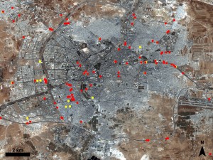
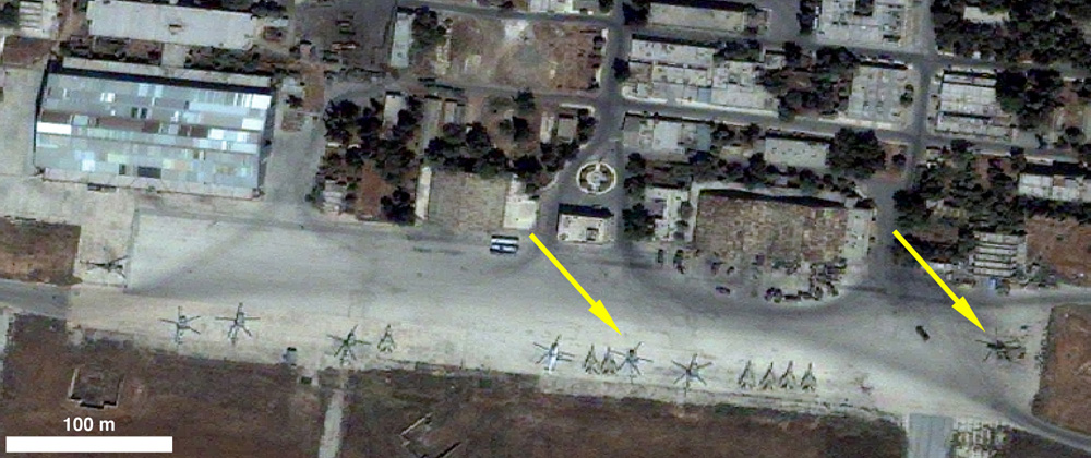
Newly released satellite images of Aleppo show a highly militarized city, with dozens of roadblocks throughout the city and military vehicles operating in its streets. We used satellite images a couple of months ago to ring the alarm over the increased risk of turning a highly populated area, such as Aleppo, into a battlefield. Our warning turned out to be justified. The weeks that followed saw indiscriminate attacks that have killed and injured scores of civilians in Aleppo and elsewhere in northern Syria.
Today’s analysis, released by the American Association for the Advancement of Science and based on imagery from August 9 and 23, provides a detailed follow up to our initial assessment from earlier in July. As the conflict in Syria escalates, the increased deployment of battlefield equipment and tactics in urban areas emerge in satellite images. Here are some of the key findings of the new analysis:
- Over a hundred roadblocks and fortifications, spread out through various neighborhoods
- A heavy presence of military vehicles and aircraft in and around the city, such as tanks or suspected attack helicopters
- Damage to infrastructure
- Scorch marks that likely stem from fire and explosions (some buildings can be seen in the images as actually on fire.
Syria’s deadliest month
The findings are indicative of how civilians in Syria are facing an exponentially higher risk

CLICK TO ENLARGE Satellite imagery shows the widespread proliferation of roadblocks throughout the city. Yellow circles indicate roadblocks dismantled between 9 and 23 August, while the 102 red circles denote intact one. (c) 2012 GeoEye, produced by AAAS.
than several months ago. The bottom line is that if battlefield weapons and munitions are used in residential areas, the number of civilian casualties significantly increases. It comes as no surprise then, that according to the United Nations, August was not only the deadliest month, but also the month that led to the highest number of people fleeing Syria since the beginning of the uprising in March 2011. More than 250,000 Syrians are now registered refugees in neighboring countries, a number that could sky-rocket to 600,000 by the end of the year.
Our own crisis researcher documented individual cases of what devastating impact unlawful military tactics have on civilians. Her account from Aleppo includes evidence of entire homes that are bombed to nothing more than dust. Just last week, she reported from other towns and villages in northern Syria, where government forces have carried out indiscriminate attacks that killed civilians—in other words: war crimes.
Why are satellite images relevant?
This new assessment of risk to civilians in Aleppo is only the most recent effort to use remote sensing for human rights documentation. In fact, I have documented around thirty efforts by human rights organizations that have capitalized on satellite technology to document violations over the last decade. Another trend is that international investigations are increasingly using evidence collected through satellites in their work. Most recently, the UN Commission of Inquiry relied in part on satellite images to reconstruct events around the Houla massacre and to determine responsibility – subsequently finding that Government forces and Shabbiha members were responsible for the killings in Houla. Human Rights Watch also recently referenced satellite images to determine culpability for the Daraya massacre.
Previous investigations that used satellite images include the conflicts in Darfur, South Ossetia, and Libya. Here’s an excerpt from the Darfur inquiry:
The Commission has received and examined a great number of reports which document both the systematic and widespread destruction of entire villages and hamlets in the three states of Darfur. A number of reports have presented satellite imagery clearly documenting this widespread destruction.
Many of these investigations by international organizations regularly result in the creation of judicial proceedings, including at the International Criminal Court (as was the case with Darfur), or are used as evidence to prosecute the alleged perpetrators. Sticking with the Darfur example, then-ICC Prosecutor Luis Moreno Ocampo used satellite imagery of destroyed villages in his July 2008 application for an arrest warrant for Sudanese President Omar Al-Bashir on charges of war crimes, crimes against humanity and genocide.
In a highly imaged area such as Syria that leads to daily image collections, it is possible to “go back in time” through the archive of commercial satellite image providers. As the Houla example shows, this is significant to determine the responsibility of the various parties to the conflict, and potentially identify specific military units or militias operating in the area. This will be crucial for upcoming court proceedings, which aim to determine individual criminal responsibility for the atrocities committed in Syria—and I am convinced that this is only a question of when this going to happen, not if.
PS: Make sure to sign our current online action in support of a congressional resolution calling for the International Criminal Court to investigate the situation in Syria.

Satellites help = unlimited 'Leave it to Beaver' starring Barbara Billingsley, Hugh Beaumont, Tony Dow, and Jerry Mathers as 'The Beaver'.
Good porn with American whores!
Excellent content about satellite! In modern time satellite is a part of our life. Whatever you have shared here about satellite seems to me pretty and outstanding. Thanks for this lovely allocation. Carry on.
This will help people a lot, but unfortunately the technology is not widely available yet!
Normally I wouldn't approve this, but given the situation there I think we should act by any means necessary to reduce violence and deaths.
I look at this as spying, but anything is allowed when the situation is so desperate. If this can help, do it!