About Christoph Koettl

Christoph Koettl is a Senior Analyst with Amnesty International's global Crisis Response Program, and is based in Washington, DC. He specializes in the use of geospatial technologies and open source resarch, and is the founder and editor of Amnesty International’s Citizen Evidence Lab, the first dedicated resource on social media verfication for human rights researchers. He previously worked and studied in Austria, the Netherlands and Italy, and holds an MA in International Relations from Johns Hopkins University’s School of Advanced International Studies (SAIS).He feels passionate about crisismapping, digital storytelling and photography.
Author RSS Feed
Follow @ckoettl on Twitter

DatNav: How to Navigate Digital Data in Human Rights Research

datnav_social_graph

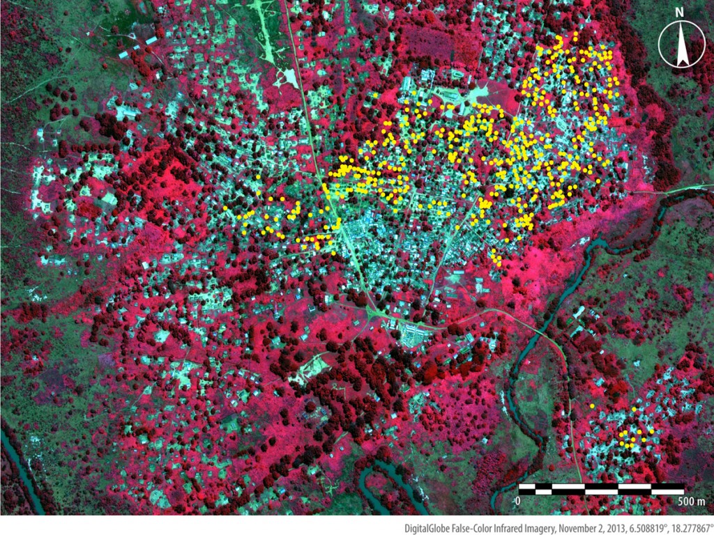
From online videos of war crimes, to satellite images of rights violations in areas as reclusive as North Korea, to eyewitness accounts disseminated on social media, we have access to more relevant data today than ever before.

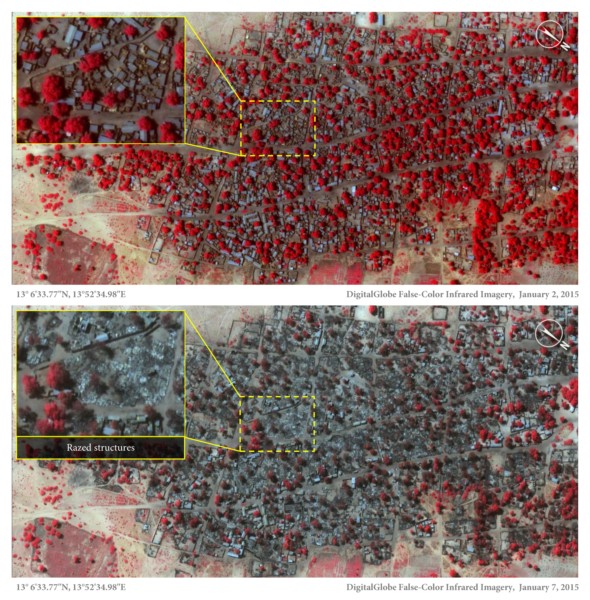
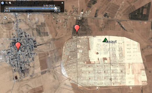
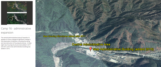
These new data streams open up new opportunities for human rights documentation, and have a profound impact on how we conduct research at Amnesty International. For example, we recently used cell-phone video footage and satellite images to uncover a likely mass grave in Burundi. Due to lack of physical access, our work on Syria also relies heavily on content shared through social media and satellite image analysis. SEE THE REST OF THIS POST

Tech and Human Rights: The Good, The Bad and The Ugly

drm_header (1)

As someone whose job it is to take advantage of technological progress for human rights research and advocacy, I am a strong proponent of using new tools and methods to advance Amnesty International’s goals. There is a proven track record of how technology can help human rights researchers and defenders in their daily work. However, any debate on this topic should not overlook the increasing challenges and threats that new technologies and digital networks pose for our profession. I am increasingly interested in exploring this undeniable tension, and I am fortunate enough to moderate a panel related to this topic Amnesty International USA’s Annual General Meeting in Brooklyn this weekend (full details below). SEE THE REST OF THIS POST

The Story Behind The Nigeria Satellite Images

Satellite image of the village of Doro Baga (aka Doro Gowon) in north-eastern Nigeria taken on 2 Jan 2015. Image shows an example of the densely packed structures and tree cover. Satellite image 2, taken on 7 Jan 2015, shows almost all of the structures razed. The inset demonstrates the level of destruction of most structures in the town. The red areas indicate healthy vegetation.

The town of Doron Baga, Nigeria, before it was largely razed by Boko Haram. 2 January 2015 © DigitalGlobe

Amnesty International today released satellite images that show the impact of a horrific Boko Haram attack in northeast Nigeria last week. The images, combined with several testimonies, provide shocking evidence of how the conflict is dramatically escalating, with dire consequences for civilians. SEE THE REST OF THIS POST

Real vs. Fake: How To Authenticate YouTube Videos

Citizen Footage

During crises or disasters, YouTube is widely used to share footage – including a host of videos that are old or, in some cases, staged or faked. An enormous challenge for human rights workers, journalists or first responders alike is to separate fact from fiction. Now, there’s a website that can help.

The Citizen Evidence Lab – launched today – is the first dedicated verification resource for human rights workers, providing tools for speedy checks on YouTube videos as well as for more advanced assessment.

SEE THE REST OF THIS POST

Tech and Human Rights at #SXSW

A cellphone can be both a powerful tool and a huge risk for human rights activists. Images and videos captured through mobile phones can reveal police brutality or even war crimes, as the uprisings in the Middle East and North Africa have shown.

However, information saved on activists’ cell phones can also expose dissident networks or other sensitive data. During the recent protests in Ukraine, police reportedly used locations revealed through cell phones to track protestors.

The “digital arms race” between activists and repressive governments is the main focus of our SXSW panel Caught in the Act: Mobile Tech and Human Rights on Tuesday, March 11.

SEE THE REST OF THIS POST

How to Tell Which Crisis Images Are Real – And Which Are Fake

During Hurricane Sandy, NPR posted this image showing soldiers at Arlington National Cemetery guarding the tomb of the unknown soldiers. Though the outlet reported it was taken during the storm, it was actually taken several months before (Photo Credit: NPR).

During Hurricane Sandy, NPR posted this image showing soldiers at Arlington National Cemetery guarding the tomb of the unknown soldiers. Though the outlet reported it was taken during the storm, it was actually taken several weeks before (Photo Credit: NPR).

A few days ago, the Afghan government published an investigation into an airstrike by international forces on January 15, 2014, that reportedly killed several Afghan civilians. The investigation relied heavily on photographs and a video showing the aftermath of the strike.

In the context of the Houla massacre in Syria in May 2012, the BBC published a distressing image, showing a child jumping over a row of dead bodies.

During Hurricane Sandy in October 2012, NPR posted an image showing soldiers at Arlington National Cemetery weathering the storm and guarding the tomb of the unknown soldiers.

SEE THE REST OF THIS POST

Massive Syrian Refugee Crisis Visible From Space

Zaatari refugee camp in Jordan, March 2013. Click to explore. Image © DigitalGlobe 2013 © Google Earth

Zaatari refugee camp in Jordan, March 2013. Click to explore. Image © DigitalGlobe 2013 © Google Earth

The massive displacement crisis stemming from Syria’s ongoing conflict is increasingly visible from space. Satellite images on Google Earth reveal the growth of what in some cases looks like the emergence of whole new cities over the last two years.

A new project published today by one of our volunteers, Richard Cozzens, presents some of the most compelling images, providing a grim snapshot of the dire humanitarian situation in and around Syria. The satellite images show camps in the countries that are most affected by the influx of refugees, such as Turkey and Jordan. For example, what was an empty spot in the desert in September 2011 is now the huge refugee camp Zaatari in Jordan.

SEE THE REST OF THIS POST

New Satellite Images Reveal Shocking Aftermath Of Abuses In Central African Republic

In the Bouca area, approximately 485 structures—represented here by yellow dots—appear burned in imagery from November 2013. Image (c) DigitalGlobe 2013.

In the Bouca area, approximately 485 structures—represented here by yellow dots—appear burned in imagery from November 2013. Image (c) DigitalGlobe 2013.

“These new images offer a glimpse of physical scarring to homes and civic life visible from space, but the true scale of the human impact of the crisis cannot be captured by satellite.” – Aster van Kregten, Deputy Africa Program Director at Amnesty International.

Expert analysis of new satellite imagery we have obtained from the Central African Republic (CAR) reveals the shocking aftermath of recent human rights abuses amid spiraling violence by armed groups and security forces.

The images – some less than a week old – include evidence of 485 homes being torched in Bouca as well as internally displaced persons (IDPs) massing near the town of Bossangoa as people flee the ongoing violence.

SEE THE REST OF THIS POST