DatNav: How to Navigate Digital Data in Human Rights Research

datnav_social_graph

From online videos of war crimes, to satellite images of rights violations in areas as reclusive as North Korea, to eyewitness accounts disseminated on social media, we have access to more relevant data today than ever before.

These new data streams open up new opportunities for human rights documentation, and have a profound impact on how we conduct research at Amnesty International. For example, we recently used cell-phone video footage and satellite images to uncover a likely mass grave in Burundi. Due to lack of physical access, our work on Syria also relies heavily on content shared through social media and satellite image analysis. SEE THE REST OF THIS POST

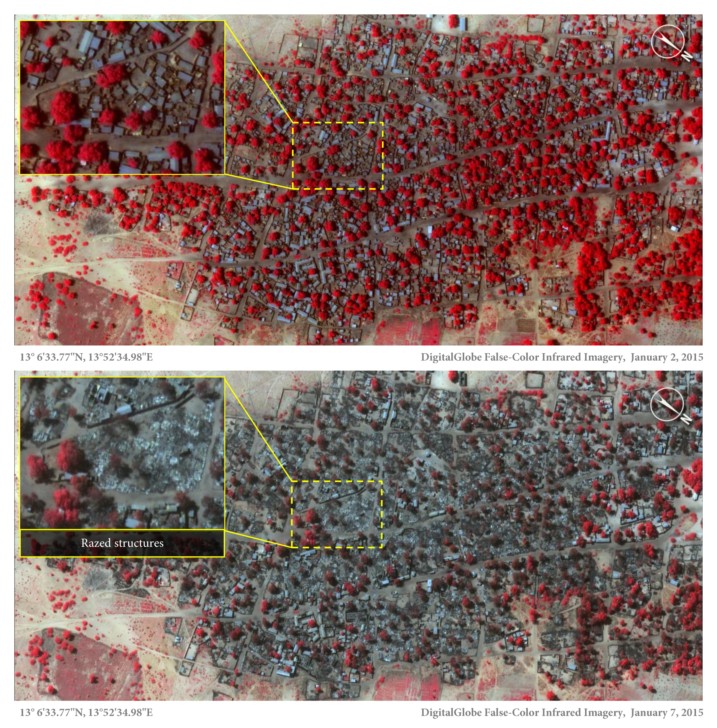
The Story Behind The Nigeria Satellite Images

Satellite image of the village of Doro Baga (aka Doro Gowon) in north-eastern Nigeria taken on 2 Jan 2015. Image shows an example of the densely packed structures and tree cover. Satellite image 2, taken on 7 Jan 2015, shows almost all of the structures razed. The inset demonstrates the level of destruction of most structures in the town. The red areas indicate healthy vegetation.

The town of Doron Baga, Nigeria, before it was largely razed by Boko Haram. 2 January 2015 © DigitalGlobe

Amnesty International today released satellite images that show the impact of a horrific Boko Haram attack in northeast Nigeria last week. The images, combined with several testimonies, provide shocking evidence of how the conflict is dramatically escalating, with dire consequences for civilians. SEE THE REST OF THIS POST

Eritrea’s Independence: 20 Years of Brutal Repression

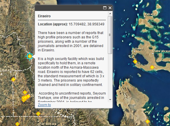
Explore the interactive map of suspected places of detention in EritreaExplore the interactive map of suspected places of detention in Eritrea (Photo Credit: Amnesty International USA).

Explore the interactive map of suspected places of detention in Eritrea.

As the 20 year anniversary of Eritrea’s independence from Ethiopia approaches, the euphoria and – one may speculate – hope, that characterized celebrations on May 24, 1993 could hardly be more incongruent with the bleak reality faced by the Eritrean people today.

The scope of repression in Eritrea is truly striking. Thousands of prisoners of conscience and political prisoners have disappeared into a vast and secret system of detention, many never to be heard from again. This system of abuse is used to silent all dissent and punish anyone who refuses to comply, including suspected critics of the government, journalists, pastors and other members of “unregistered” religious groups, those who have been caught attempting to flee the country and those forcibly returned to Eritrea from other countries.

SEE THE REST OF THIS POST

Joseph Kony Was Here

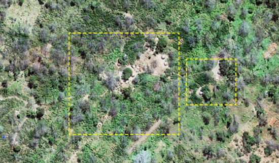
Satellite image of likely LRA camp in Kafia Kingi. Click to see full image . (Photo Credit: Digitial Globe 2013).

Satellite image of likely LRA camp in Kafia Kingi. Click to see full image . (Photo Credit: Digitial Globe 2013).

Now where will the US go on the ICC?
While international justice has seen many milestones over the last months, including the surrender of “The Terminator” Bosco Ntaganda, one of the most well known fugitives from the International Criminal Court (ICC) remains on the loose. Joseph Kony, the Lord Resistance Army’s (LRA) notorious leader, has so far evaded arrest. However, as of today, attempts to locate his whereabouts have gotten a considerable boost. In fact, thanks to satellite imagery, we might know the exact coordinates of his recent location.

SEE THE REST OF THIS POST

Why The New Investigation Into North Korean Human Rights Violations Matters

This posting is part of the North Korea Revealed blogging series, published in the context of efforts to establish a Commission of Inquiry at the current session of the UN Human Rights Council (February 25 – March 22). Join the conversation through #NKRevealed.

With overwhelming support from member states, the UN Human Rights Council in Geneva today established a Commission of Inquiry to investigate the deplorable human rights conditions in North Korea. Today’s development should be considered a milestone for international justice. While an independent investigation will not yield the ultimate impact we want—the much-needed closure of the political prison camps—it represents a crucial first step in uncovering the widespread and systematic nature of the crimes, and could ultimately lead to holding the perpetrators accountable. As an immediate impact, the commission has the potential to pressure North Korean officials to end their outright denial of the existence of the camps. We heavily campaigned for this outcome over the last few months – by putting the vast network of political prison camps on the map, uncovering a new security zone next to the infamous Camp 14, and most importantly, by sharing the powerful stories of survivors of the forgotten prisons, with the world.

SEE THE REST OF THIS POST

Is North Korea Turning Into One Big Prison?

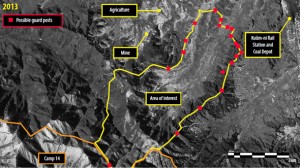
(c) DigitalGlobe 2013. Panchromatic Imagery, February 7, 2013. 39 38 02 N, 125 59 52 E

(c) DigitalGlobe 2013. Panchromatic Imagery, February 7, 2013. 39 38 02 N, 125 59 52 E

This posting is part of the North Korea Revealed blogging series, published in the context of efforts to establish a Commission of Inquiry at the current session of the UN Human Rights Council (February 25 – March 22). Join the conversation through #NKRevealed.

Amnesty International is releasing new satellite images today that raise fears that the North Korean government is starting to blur the line between the country’s horrendous political prison camps and regular villages. This disturbing new development gives further fuel to a previous warning by a UN expert that authorities are turning the country into “one big prison,” and stress the urgent need for the UN Human Rights Council to establish an independent Commission of Inquiry.

We commissioned satellite imagery analysis from DigitalGlobe after reading reports about a potential new political prison camp. The original speculations were based on Google Earth satellite imagery from the fall of 2011. We were able to secure imagery from February 2013, allowing us to provide the most up-to-date snapshot possible of worrisome developments in a valley adjacent to prison camp 14.

SEE THE REST OF THIS POST

Aleppo: Why We Should Be Alarmed

syria aleppo

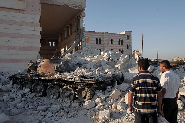
Syrian men look at a destroyed Syrian army tank parked outside the Azaz mosque, north of the restive city of Aleppo, on August 2, 2012. (c) AHMAD GHARABLI/AFP/GettyImages

News reports coming out of Aleppo paint a grim picture of the confrontation between opposition fighters and the Syrian armed forces, who are describing this as the “decisive battle”. If the past 16 months are any indication, we have to brace ourselves for a new wave of human rights violations, as well as grave breaches of international humanitarian law. As has been extensively documented by Amnesty International and others, the atrocities committed in Syria have steadily continued to climb.

For example, one of my colleagues who recently returned from Aleppo, documented crimes we believe amount to crimes against humanity. Her reporting from late May describes how government security forces and the notorious government-backed shabiha militias routinely used live fire against peaceful demonstrations in Aleppo, killing and injuring protesters and bystanders, including children, and hunting down the wounded, the medics who treated them, and opposition activists. SEE THE REST OF THIS POST

#DemandJustice: The Website War Criminals Don’t Want You To Share

Six years ago, the International Criminal Court (ICC) issued an arrest warrant for Congolese warlord Bosco Ntaganda. Today, the effect of the failure to arrest him can be seen in the eastern Democratic Republic of Congo (DRC), where he and other members of armed groups remain free to commit further human rights violations against civilians.

The DRC is one of several situations featured on our new Demand Justice website. It was launched on International Justice Day earlier this week in order to provide us with a more powerful tool to mobilize  activists around the globe to bring Bosco Ntaganda and others to trial.

If convicted war criminals, such as Thomas Lubanga Dyilo had a Twitter account, he probably would not share our new site. If war crimes suspects Joseph Kony and Omar al-Bashir were active on Facebook, they would hardly “Like” our Fugitives from International Justice infographic. Why not?
SEE THE REST OF THIS POST

Crisis Mapping 2011 – State Of The Art

Over the last years we have explored the use of Information and Communications Technologies for human rights research and campaigning, using satellite images to document human rights violations, ranging from attacks against civilians during armed conflict to housing demolitions, to the impact of oil spills on communities.

At Amnesty International we are looking more and more to expand our work, trying to take advantage of technological progress and new communications tools. We’re not alone.  Others around the world are also using cutting edge technologies to bring about change and many are meeting this week in Geneva at the annual Crisis Mappers conference.

So instead of writing my own blog entry, I thought I’d give you a peak on what’s happening in the world of crisis mapping.

SEE THE REST OF THIS POST

(S)Hell In The Niger Delta: Satellite Images Document Oil Spills

Bodo Nigeria Before-After

Right: (4 December 2006): A false-color image of the waterways around Bodo. Healthy vegetation appears bright red. Left: (26 January 2009): This image, taken during the second oil spill in Bodo, shows vegetation death concentrated mainly near the river and its tributaries. (c) 2011 GeoEye and Digital Globe (Produced by AAAS).

Newly released satellite images visualize the devastating impact of the 2008 oil spills in Bodo, Nigeria, part of a pattern of destruction by oil companies in the region.

The images from 2006, 2009 and 2011 document the destruction of large swathes of vegetation near Bodo’s riverbanks. The true and false-color satellite images show rainbow slicks in the water ways, discoloration of the intertidal zone and vegetation death around Bodo. Three years after the oil spills, the pollution is still visible in the images.

SEE THE REST OF THIS POST